Pyramid Environmental & Engineering

  • Facebook
  • LinkedIn

(866) 545-9507

  • Home
  • About
    • Our Staff:
    • Certifications and Affiliations
    • Company History
    • Testimonials
  • Services
    • Industrial and Environmental Compliance
    • Due Diligence Environmental Services
    • Soil and Groundwater Services
    • Geophysical Services
    • Private Utility Locating
    • Brownfield Redevelopment and Land Revitalization
  • Who We Serve
  • Pyramid Geophysics
  • Newsletters
  • Careers
  • Contact
You are here: Home / Newsletter Archive / August 2016 Newsletter: Former Landfills & Buried Waste – How Do We Find It?

August 2016 Newsletter:
Former Landfills & Buried Waste – How Do We Find It?

landfill waste, geophysics for buried waste
Former landfill waste can be identified using geophysical methods.

North Carolina contains hundreds of properties that served as landfill sites in the past; these former landfills have long since been inactive, and many of the sites are overgrown with no specific knowledge of the extent of the buried waste. In North Carolina, the Department of Environmental Quality (DEQ) has established a program to assist in assessing and remediating these pre-regulatory landfills. The DEQ definition of a pre-regulatory landfill is, “any land area, whether publicly or privately owned, on which municipal solid waste disposal occurred prior to January 1, 1983, but not thereafter, and does not include any landfill used primarily for the disposal of industrial solid waste.”

EM31, conductivity, buried waste
EM31 in the field, surveying for buried waste at a former landfill

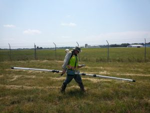
Prior to any comprehensive assessment and remediation of these sites, the regulators must first have a clear understanding of the boundary limits of buried waste. Geophysical surveys are the most common method to determine the limits of buried waste. Specifically, most investigations will incorporate an electromagnetic survey to measure ground conductivity across the area thought to contain buried waste. This survey is typically performed using an electromagnetic terrain conductivity meter. Pyramid Geophysical Services uses a Geonics brand EM31.

The EM31 terrain conductivity meter measures apparent ground conductivity and provides metal detection down to a maximum depth of 15 to 17 feet below surface. The EM31 method determines electrical properties of the earth materials by inducing electromagnetic currents in the ground and measuring the secondary magnetic field produced by these currents. The two data sets that are collected can be used to observe changes in ground conductivity that are the result of something such as the presence of buried waste in a landfill.
EM31 contour map, buried waste map, conductivity map
EM31 contour map of conductivity, interpreted to show the limits of buried waste.

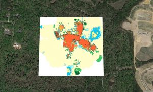
The final product generated from an EM31 survey is typically a plan-view color contour map of conductivity variance across the site. The presence of buried waste (relative to the surrounding native soil) will cause an increase in the ground conductivity. Other factors can also result in increased ground conductivity, such as changes in soil type and moisture content; these factors must also be taken into account when interpreting the limits of buried waste. The results can also be analyzed to specifically identify buried metal such as drums or metallic debris.

Frequently, a ground penetrating radar (GPR) survey is also performed at the former landfill site subsequent to the EM survey. GPR can help to image the interface between the buried waste and native soil in the subsurface along the boundary of the landfill. By imaging this interface, an even more accurate location of the waste limits can be identified. GPR scans can be performed around the perimeter of the buried waste, perpendicular to the boundary, to isolate and image the waste limit. Ultimately, the geophysical and GPS results are used to identify the geographic coordinates associated with the waste boundary. These coordinates are provided to the DEQ as a guide to use for physical sampling of the site and establishing a remediation program.
Pyramid has performed geophysical surveys to delineate buried waste at a variety of inactive landfill sites, as well as other properties that were thought to contain extensive waste or debris. If you have any questions about the geophysical procedures, requirements, or results associated with these surveys, please do not hesitate to contact us today!

On Topic:

  • <div> June 2019 Newsletter: </div> How the Roads that lead to Rome were made
    June 2019 Newsletter: How the Roads that lead to Rome were…
  • <div> October 2020 Newsletter: </div> Supplemental Tools for Geophysics - How We Present the Results
    October 2020 Newsletter: Supplemental Tools for Geophysics -…
  • <div> October 2019 Newsletter: </div> Seismic Geophysical Surveys to Examine Bedrock Depth and Integrity
    October 2019 Newsletter: Seismic Geophysical Surveys to…
  • <div> January 2020 Newsletter: </div> More interesting information about bedrock fractures and how to analyze them
    January 2020 Newsletter: More interesting information about…
  • <div> July 2020 Newsletter: </div> Density Anomalies and Geophysics - Concepts and Methods
    July 2020 Newsletter: Density Anomalies and Geophysics -…

Filed Under: Newsletter Archive Tagged With: conductivity, EM31, landfill, mapping buried waste

#gsa #contract

Newsletter

Subscribe

Recent Articles

  • October 2020 Newsletter:
    Supplemental Tools for Geophysics – How We Present the Results
  • July 2020 Newsletter:
    Density Anomalies and Geophysics – Concepts and Methods
  • January 2020 Newsletter:
    More interesting information about bedrock fractures and how to analyze them
  • October 2019 Newsletter:
    Seismic Geophysical Surveys to Examine Bedrock Depth and Integrity
  • June 2019 Newsletter:
    How the Roads that lead to Rome were made

Certifications and Affiliations

AFFILIATED COMPANIES

LPT Systems

Provider of lubrication, pump and tank systems and equipment, sales and service

Pyramid Geophysical Services

A subsidiary of Pyramid Environmental, Pyramid Geophysical specializes in subterranean/subsurface metrics and monitoring through a variety of technologies

© Pyramid Environmental & Engineering P.C. | site by jbQ Media Web & SEO